For months, climate and weather experts have been warning about a historically strong Super El Niño that could turbocharge extreme weather across the world, intensifying everything from storms to floods to droughts.
Now AccuWeather has released its long-range Winter 2026-27 forecast, shedding more light on how that El Niño could affect this winter season across the U.S., and what specific conditions it may fuel.
“The stronger we see an El Niño signal, which is one of our top drivers when we look at seasonal forecasts, the more confidence we feel that certain things are going to take place,” says Paul Pastelok, AccuWeather senior meteorologist and long-range forecaster.
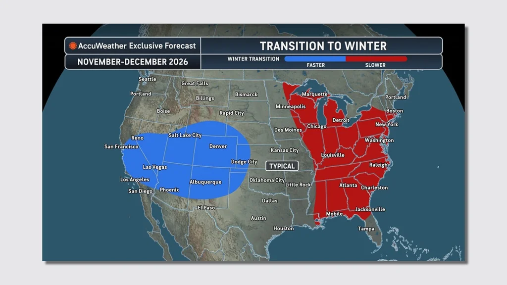
Meteorological winter doesn’t begin until December 1, so there’s still time for weather conditions to change, Pastelok adds.
But he and his team have spent about a month working on this forecast, looking at the trends of past years and previous El Niños, and relying on more than 100 climate models.
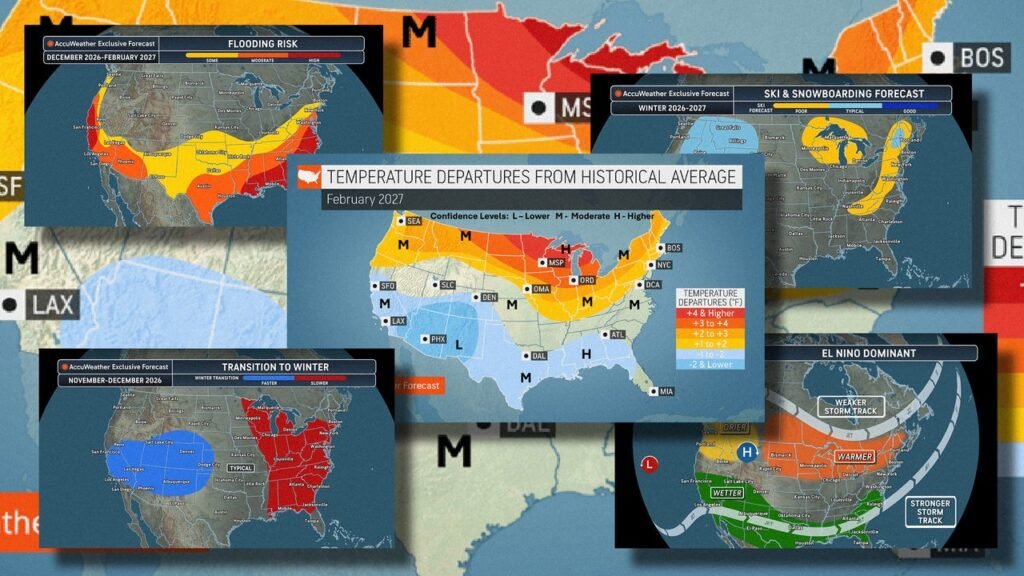
Here are five maps that illustrate the winter forecast, and El Niño’s potential impact.
What a typical El Niño looks like
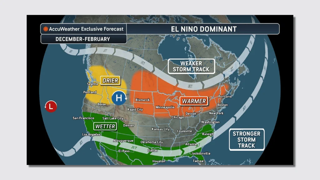
El Niño is a climate phenomenon defined by above-average sea surface temperatures in the Pacific Ocean, and a weakening of trade winds that flow from east to west. All those changes affect atmospheric conditions, disrupting global weather patterns.
For the U.S., this typically leads to wetter conditions across the south and drier-than-normal conditions farther north.
This map illustrates those typical conditions, showing a “wetter” band across the southern half of the country, from San Francisco on the West Coast to Raleigh, North Carolina, on the East Coast; a “drier” spot in the Pacific Northwest; and a “warmer” region around the Great Lakes and into the Northeast.
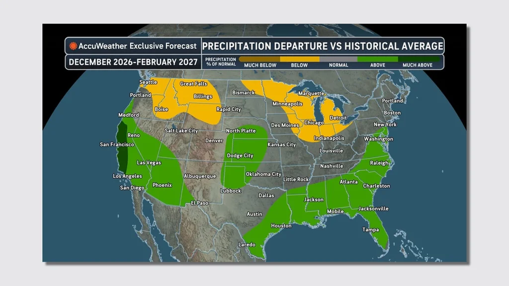
This year’s El Niño has the potential to be the strongest one since 1950—even surpassing the 1982-83 El Niño, which researchers have described as the “strongest and most devastating of the century.”
That El Niño caused “weather-related disasters on almost every continent,” according to the Woods Hole Oceanographic Institution, as well as roughly 2,000 deaths and more than $13 billion in damage.
El Niño isn’t the only thing that can affect winter weather, though.
“We’ve noticed over the last few El Niño that have taken place, the 2023-24, the 2015-16, that some other drivers start to poke their nose into the picture, and when they do, it gives you kind of different outcomes,” Pastelok says.
Two strong marine heat waves, for example—one off the coast of Baja, Mexico, and another in the northwestern part of the Pacific—could push that storm track farther north, meaning Southern California may not get as much precipitation.
“Most of the time, El Niño is aimed at Southern California, but we think it could get directed at times farther north up the coast, which could mean the Central Sierras could get buried again this year,” he says.
Snow amount forecast map
This map shows the forecasted snow amounts, compared to historical averages.
The northern parts of the country and into the Midwest and mid-Atlantic could see below-average snowfall, while the Sierra to the Great Basin and central and southern part of the Rockies could see above-average snowfall.
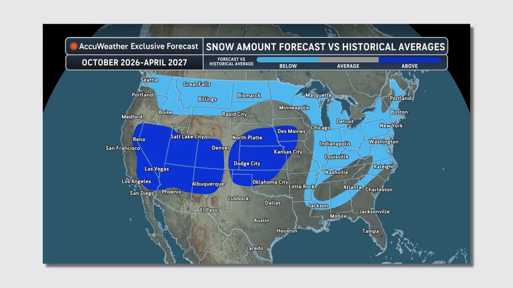
That would help build the snowpack in those mountains, which would be a positive outcome after a historically hot and dry spring and summer. The Colorado Basin currently has record-low water levels.
Forecasters expect more variability in the storm track for the Northwest, though, which could mean periods of snow followed by extended periods of drier weather.
The first half of the winter has the best chance for consistent snow; all those factors are why snowfall will be near to below average in that region.
Another feature of El Niño winters, Pastelok says, is the way the southern track storms can pick up moisture out of the Gulf and Atlantic.
“If one [storm] just happens to come up the East Coast, it’s not a 5-to-10-incher. It could be a 1- to 2-foot or 2- to 3-foot snowstorm,” he says. “You get it all at once, and then it doesn’t do anything for several weeks.”
Ski and Snowboard Forecast Map
As a follow-up to the snow totals, AccuWeather also made a specific map on the ski and snowboard conditions expected throughout the winter season.
This map generally reflects the same impacts as the snow totals: better ski and snowboarding conditions in the West, from the Sierra Nevadas to the Rockies, where more snow is expected, and poorer ski and snowboarding in the East.
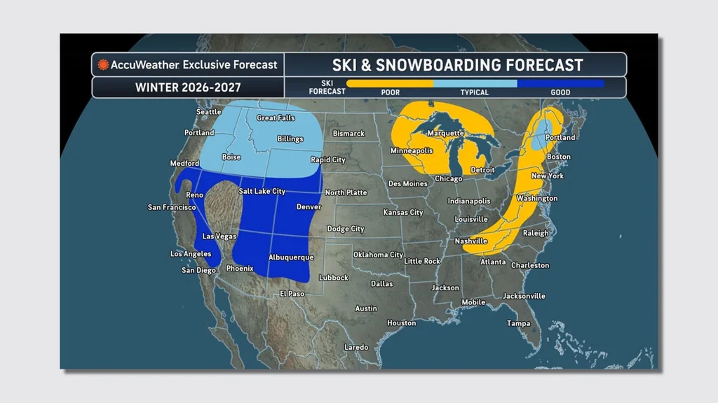
Potential early-season snow in November could help some New England ski resorts, AccuWeather says, but then a “lack of sustainable cold” might hurt those resorts later on, allowing only a few trails to open.
Flooding-risk map
AccuWeather doesn’t typically include a flood map in its long-range winter forecast, but the meteorologists there believed it was necessary this year, Pastelok says, because of the El Niño, which could set up the country for “potentially several heavy rain events.”
That flood risk is predominantly focused on the California coast, then across the southern half of the country into the Southeast, above the Florida Panhandle.
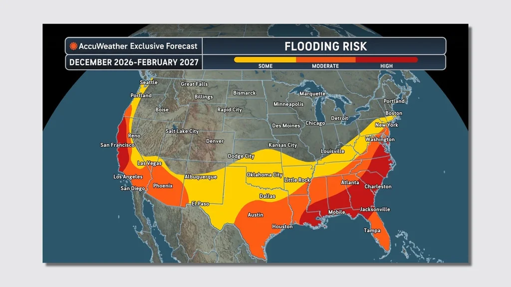
El Niños can intensify the atmospheric rivers—essentially “rivers in the sky,” according to the National Oceanic and Atmospheric Administration—that bring this rain. These “relatively long, narrow regions in the atmosphere . . . transport most of the water vapor outside of the tropics,” NOAA’s website explains.
This El Niño could come with “not just one atmospheric river, but six, seven, or eight that cause major flooding,” Pastelok says.
Heavy rain brings another concern: When it hits areas that have been burned by wildfires, that can form intense mud and even mudslides.
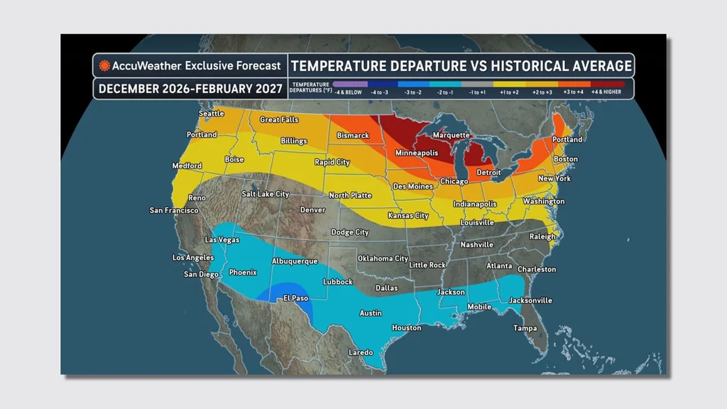
Winter Temperature map
The 2025-26 winter was actually the second-warmest in U.S. history, with above-average temperatures in the Southwest—but it also brought frigid stretches of cold to the Northeast.
This winter may see the opposite trend: The map shows how the southern half of the country could experience below-average temperatures, while the northern half sees above-average temperatures.
In the region right around the Great Lakes, temperatures could even hit 4-plus degrees higher than historical averages.
The extreme, record cold that some parts of the country saw last winter was due to a polar vortex, a large mass of cold and fast winds that swirls around the Arctic Circle.
The polar jet stream, a river of air that sits below that polar vortex, turned wavy, bringing frigid Arctic air farther south than usual.
With El Niños, though, “You don’t typically see a lot of Arctic air masses that get pulled down,” Pastelok says.
Even without Arctic air coming down, though, there’s a potential for severe ice.
“When you get to the time period of mid-January through February, you don’t really need to have true Arctic air to come down. It just can be marginal cold and sets up right,” Pastelok says.
That could mean one or two Southern storms, from Arkansas through Tennessee into the Appalachians, that bring ice, with the potential to take down power lines.
Exactly what this El Niño winter will bring remains to be seen, of course, but the forecast will become clearer as it gets closer.
For his part, Pastelok predicts record-breaking conditions, either in terms of flooding, rainfall amounts, or even “because temperatures are too warm, not too cold.”