This year’s Super El Niño “looms large” over the winter forecast for the United States, forecasters from the National Oceanic and Atmospheric Administration (NOAA) wrote this week.
And for about half of the country, that’s shaping up to make for a wet winter.
El Niño is a climate phenomenon defined by above-average sea surface temperatures in the Pacific Ocean, and a weakening of trade winds that flow from east to west. All those changes affect atmospheric conditions, disrupting global weather patterns.
How will the phenomenon impact U.S. weather patterns?
El Niños typically present with wetter conditions across the U.S. South, and drier than conditions farther north.
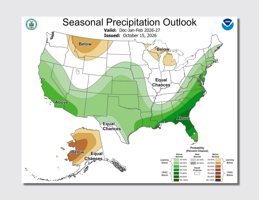
A 2026-2027 Winter Outlook map from NOAA illustrates that, showing a wavy band cutting across the U.S. that will bring “above normal” precipitation to the southern half of the country. That band swings up to cover the entire California coast and the East Coast, as well.
Certain areas will be impacted even more: parts of Florida, for example, are forecasted to experience 70-80% above normal precipitation.
“As we know from decades of observations, a very strong El Niño will likely bring a southward and eastward shift to the jet stream for the contiguous U.S., which tilts the odds toward stormier weather across the South,” Ken Graham, director of NOAA’s National Weather Service (NWS), said in a statement.
That wet weather could ease drought conditions in the southwest. Southern Great Plains, Southeast, and parts of the East Coast, according to another NOAA map.
But forecasters say that could make for other negative weather impacts.
“While higher chances of rain and snow may bring relief to drought-afflicted areas, too much precipitation on dry soil can fuel destructive flash floods and mudslides,” Graham said. “Now is the time for communities and individuals to plan ahead for the upcoming winter.”
Some communities are already preparing. Governor Gavin Newsom of California has already declared a state of emergency ahead of this El Niño winter.
With this El Niño already breaking records and potentially only getting stronger, “that can mean repeated rounds of heavy rain, strong winds, mountain snow, flooding, landslides, debris flows, large waves, and coastal flooding, especially when storms hit during very high tides” for California, according to his office.
Certain areas of the country are expected to see drier-than-average conditions, though, like Hawaii, Alaska, the northern Mountain West, and some areas around the Great Lakes.
That also means drought conditions could “develop or worsen,” forecasters wrote, across some of the northern Rockies, as well as northeastern Oregon and eastern Washington.
Those forecasts mirror others looking ahead to this winter, including a series of maps from AccuWeather that was shared with Fast Company earlier this month.
Word to the wise: The map is not the territory
Experts do note that specific outcomes aren’t a guarantee; the El Niño simply tilts the odds toward certain impacts. As the season gets closer, meteorologists will continue to update their forecasts.
For those who want to keep a close eye on any oncoming snow or rain, the NWS has now opened its Probabilistic Precipitation Portal, an interactive map that lets users see “the low-end, expected, and high-end amounts of snow, ice and rain” over a 72-hour period.